Let’s replace the bogus panel now with a GXM Component. Enter GXM.FeatureList.
A GXM.FeatureList can be configured with a olLayer-option, which tells the component it shall render a list of all the features in that particular layer:
var featureList = Ext.create('GXM.FeatureList', {
    olLayer: redliningLayer,
    title: 'Redlining'
});
And don’t forget to add the list to the TabPanel:
var tabPanel = Ext.create('Ext.TabPanel', {
    items: [
        mapPanel,
        layerList,
        featureList
    ]
});
Tasks
If all went well you application should look like this
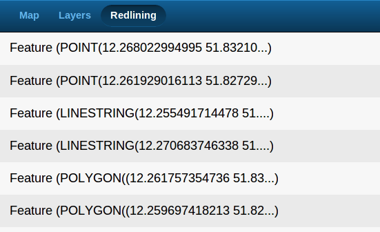
Digitized features displayed in a FeatureList (standard template)
The list is fully functional, but it displays its features in a probably undesired fashion. You usually want to have a different representation of your features, than the default textual represenattion of the features’ geometries.
The GXM.FeatureList accepts an itemTpl-configuration which handles the visual representation of the elements managed in the list.
Here is an example that renders features differently:
var featureList = Ext.create('GXM.FeatureList', {
    olLayer: redliningLayer,
    title: 'Redlining',
    itemTpl: new Ext.XTemplate(
        '{[this.renderFeatureListItem(values.feature)]}', {
            renderFeatureListItem: function(feature){
                var geom = feature.geometry,
                    type = geom.CLASS_NAME.substr(
                        geom.CLASS_NAME.lastIndexOf('.') + 1
                    ),
                    addInfo = '';
                    if (type === 'Polygon') {
                        addInfo += ", Area " +
                            geom.getArea().toFixed(5) + 'sq°';
                    } else if (type === 'LineString') {
                        addInfo += ", Length " +
                            geom.getLength().toFixed(5) + '°';
                    }
                return Ext.String.format('{0}-Feature {1}', type, addInfo);
            }
        }
    )
});
Tasks
If all went well you application should look like this
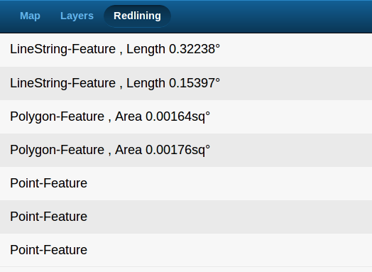
Digitized features displayed with a non-standard itemTpl
In the next section we’ll add some interaction with the list: we’ll do something, when listitems are tapped.